Coastal intelligence services

Cosmeo’s services are based on three areas of environmental data production, covering coastal morphology, oceanographic dynamics and coastal ecosystems. A fourth, cross-cutting area is dedicated to the operational use of this data to support coastal management.

Coastal morphology

Sea conditions

Coastal ecosystems

Decision-making support

Coastal morphology

led by

co-contractor

The service provides coastline positioning data for the entire French coastline (mainland France and overseas territories), based on high- and very high-resolution optical satellite imagery, with comprehensive coverage of unspoilt coastal areas.

It enables the monitoring of coastal changes over time to support strategies for managing coastal erosion, coastal development and coastal risk prevention.

An operational processing chain is already in place and enables the production of these indicators. It is currently being scaled up to enhance its robustness, reproducibility and ability to adapt to all types of coastlines and coastal environments (beaches, cliffs, estuaries, etc.).

Pilot sites covered in 2026, demonstration available on request:

  • Nouméa, New Caledonia
  • Brittany
  • Var and Alpes-Maritimes, Provence-Alpes-Côte d’Azur
  • Rangiroa Atoll,Tuamotu Archipelago,French Polynesia
  • Martinique


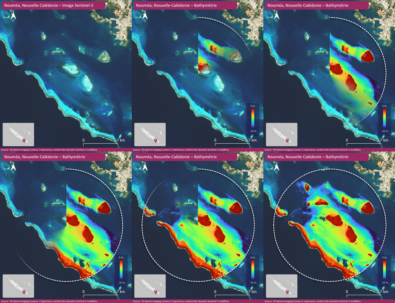
The service provides bathymetric data for shallow coastal areas based on Sentinel-2 satellite imagery, with coverage extending to a depth of approximately 20 metres and optimal performance between 0 and 10 metres.

It helps to better characterize the morphology of shallow coastal waters in order to support hydrodynamic studies, the management of sensitive coastal areas, and the understanding of sedimentary dynamics.

An operational processing pipeline already exists and enables the production of these bathymetric estimates. It is currently being scaled up to reduce the need for expert intervention, improve the automation of processing, and enhance the robustness and reproducibility of results across a variety of coastal contexts (clear waters, sandy or mixed environments, etc.).


Pilot sites covered in 2026, demonstration available on request:

  • Nouméa, New Caledonia
  • La Forêt-Fouesnant, Brittany
  • La Ciotat, Provence-Alpes-Côte d’Azur
  • Bora Bora Island, French Polynesia
  • Fort-de-France, Martinique


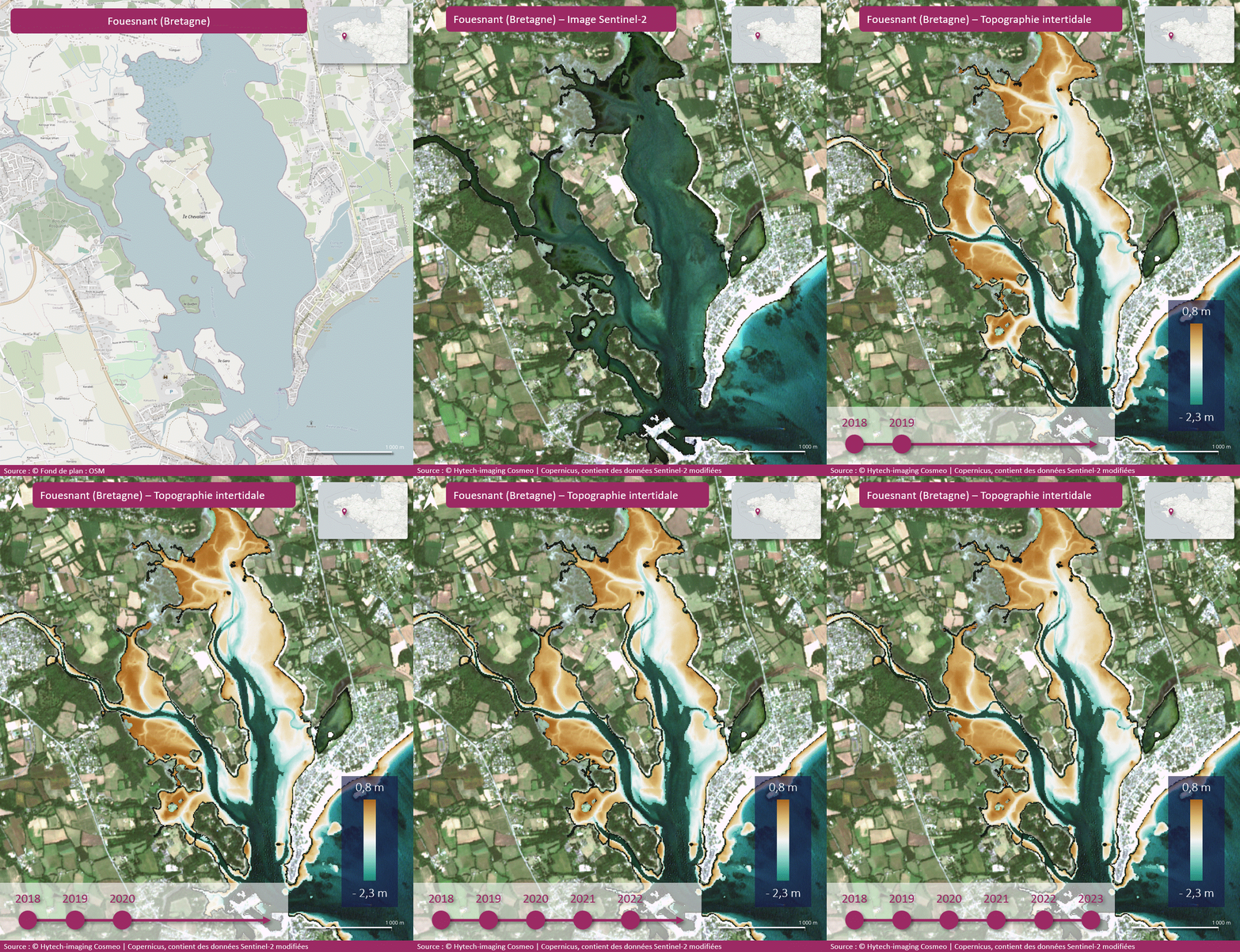
The service provides digital elevation models (DEMs) of the intertidal zone based on Sentinel-2 or equivalent satellite imagery, covering exposed areas of the foreshore with a spatial resolution of 10 metres.

It enables the analysis of foreshore topography to support the monitoring of intertidal zones, the understanding of erosion dynamics, and the management of coastal environments exposed to tides and extreme events.

A processing pipeline has been implemented and validated at several test sites. Work is now focused on scaling up the process and integrating the results with bathymetric data to create a continuous and consistent representation of the coastal topography, from the foreshore to shallow waters.


Pilot sites covered in 2026, demonstration available on request:

  • Nouméa, New Caledonia
  • La Forêt-Fouesnant, Brittany


Sea conditions and coastal dynamics

led by

co-contractor

subcontractor

The service provides coastal surface current data every 3 hours or daily, depending on the geographical area, by combining marine current data derived from the analysis of AIS data, MELODI drifting buoys in near real time, and reference products from multi-mission satellite data and models.

Frequent updates and the availability of products in interoperable formats enable the service to meet the requirements for continuity and accuracy of maritime operators and the scientific community. The service guarantees rapid turnaround times, providing users with measurement data within a few hours.

Pilot sites covered in 2026, demonstration available on request:

  • Mediterranean
  • The West Indies – French Guiana
  • Manche, Brittany, Bay of Biscay
  • Reunion Island
  • French Polynesia, New Caledonia


The service provides an analysis of swell parameters near the coast, derived from a dynamic analysis of Sentinel-1 and CFOSAT satellite observations of the offshore swell spectrum, supplemented by in-situ measurements from MELODI buoys. The service provides a time series of swell height, period and direction of propagation.

Frequent updates and the availability of products in interoperable formats ensure compliance with requirements for continuity and accuracy. The service guarantees rapid turnaround times, providing users with up-to-date data within a few hours.

Pilot sites covered in 2026, demonstration available on request:

  • Mediterranean
  • The West Indies – French Guiana
  • Manche, Brittany, Bay of Biscay
  • Reunion Island
  • French Polynesia, New Caledonia


The service provides accurate mapping of dynamic topography (1D and 2D) in coastal areas, based on altimetry data from multiple missions (including Sentinel-6 and SWOT, provided by AVISO, among others). It delivers high-resolution topographic data that can be integrated into coastal risk management and infrastructure planning platforms.

Frequent updates and the availability of products in interoperable formats enable adaptation to requirements for continuity and accuracy. The service provides track-based (L3) or map-based (L4) products that can be used for both routine and ad hoc services.

Pilot sites covered in 2026, demonstration available on request:

  • Mediterranean
  • The West Indies – French Guiana
  • Manche, Brittany, Bay of Biscay
  • Reunion Island
  • French Polynesia, New Caledonia


The service provides wind data derived from CMEMS’s multi-mission altimetry products and Sentinel-1 products from the CYMS production chain. The service complements the description of marine environmental conditions by providing information on wind speed at 10 metres above the ocean.

The service ensures rapid availability and regular updates, enabling data to be provided to users within at least 3 hours for European satellites, in order to guarantee optimal responsiveness in the targeted geographical areas.

Pilot sites covered in 2026, demonstration available on request:

  • Mediterranean
  • The West Indies – French Guiana
  • Manche, Brittany, Bay of Biscay
  • Reunion Island
  • French Polynesia, New Caledonia


Coastal ecosystems

led by

co-contractor

subcontractor

The service provides habitat mapping products by combining earth observation data (high- and very high-resolution imagery), field data (vegetation surveys or habitat presence surveys) and artificial intelligence (AI).

This product provides up-to-date mapping of coastal habitats to support environmental monitoring, the management of marine protected areas and the assessment of pressures on natural environments.

Pilot sites covered in 2026, demonstration available on request:

  • Morlaix Bay, Brittany
  • Gulf of Morbihan, Brittany
  • Quiberon, Brittany
  • Lorient, Brittany
  • Étel, Brittany
  • Marin Bay, Martinique


The service provides maps of vegetation indices for the foreshore at the site, regional and coastal zone levels, as well as metrics derived from these indices, which are useful for monitoring the health of these environments.

The service is based on Sentinel-2 data, providing spatio-temporal coverage compatible with seasonal products. It provides vegetation presence indices and will be enhanced with metrics offering new insights into the health of habitats.

This product enables the analysis of the spatio-temporal dynamics of intertidal vegetation in order to support the ecological monitoring of coastal habitats and the assessment of their conservation status, in line with the Water Framework Directive (WFD) and the biodiversity monitoring mechanisms associated with the European Nature Restoration Regulation (NRR).

Pilot sites covered in 2026, demonstration available on request:

  • Morlaix Bay, Brittany
  • La Forêt-Fouesnant, Brittany


The service provides cartographic data on non-algal particle concentrations and chlorophyll-a concentrations in mainland France, in the form of both continuous representations and statistics broken down by coastal water body.

The service is based on data from the Sentinel-2, Sentinel-3 and VIIRS constellations, with optional data from the PlanetScope constellations.

It supports water quality monitoring under the WFD, the analysis of marine and coastal pressures (aquaculture, MRE infrastructure), the monitoring of water quality for public health purposes, and the detection of eutrophication and phytoplankton blooms.

Operational processing chains are already in place. Significant work was carried out in the initial phase on spatial and temporal resolutions in order to offer a product that complements existing services such as CMEMS and ODATIS. This prototype is currently being consolidated and refined.

Pilot sites covered in 2026, demonstration available on request:

  • Vilaine Bay, Brittany


Decision-making support

led by

co-contractor

subcontractor

Very high-resolution (VHR) satellite imagery, such as Pléiades, enables a better characterisation of boat traffic in marine protected areas (MPAs) and an assessment of the pressure exerted by moorings on seagrass beds.

Combined with AIS data and local information, these observations provide an integrated and objective view of recreational uses and their potential impacts on sensitive habitats.

The full set of data (maps, indicators) will feed into an operational dashboard, updated regularly, providing an objective and concise overview of the pressure exerted on sensitive habitats.

Pilot site covered in 2026, demonstration available on request:

  • Cap-Ferrat Marine Protected Area (Natura 2000 site)


Very high-resolution (VHR) satellite imagery, such as Pléiades, offers a new approach to mapping professional land uses, particularly shellfish farming, within marine protected areas (MPAs). It complements existing methods by providing a comprehensive and objective view of the location of oyster farms.

By combining satellite data, cadastral data and local information, managers are provided with a comprehensive and reliable overview of the situation.

All the data (maps, indicators) will feed into an operational dashboard, updated regularly, providing a clear and objective view of the interactions between commercial activities and habitats.

Pilot site covered in 2026, demonstration available on request: :

  • Gulf of Morbihan Regional Nature Park


The service provides spatially-resolved information to support the understanding and monitoring of coastal erosion and marine inundation.

It draws on products from the ‘coastal morphology’ component (coastline evolution, shallow-water bathymetry), as well as complementary environmental and contextual data, in order to characterise coastal dynamics. These data are expected to be fully available from July 2026.

The service is based on a platform for presenting indicators and maps, which is already under development. However, the operational indicators are yet to be developed in collaboration with users, depending on business needs and the actual availability of data.

The results will be progressively consolidated into a dedicated dashboard, designed to facilitate the operational monitoring of hazards and support decision-making.

Pilot site to be covered in 2026; demonstration available soon on request

  • Gulf of Lion Marine Nature Reserve


To support the development of industrial activities in coastal areas, particularly marine renewable energy (MRE), satellite imagery products offer an observational capability that complements existing systems.

By combining data from the ‘coastal morphology’ and ‘coastal ecosystems’ modules with supplementary data, the service aims to provide an integrated and regularly updated overview of the coastal environment surrounding future offshore MRE infrastructure.

This service is currently being defined and explored, with a primary focus on the environmental monitoring of offshore wind farms. It has not yet been prototyped and is currently undergoing a scoping phase with future users.

The whole project will feed into a dashboard co-developed with users, designed to progressively refine the indicators and operational applications.

Pilot site:

  • RME site currently being selected